Choosing between the DJI Matrice 400 and the Matrice 4D is one of the most common questions Mirrormapper gets from enterprise clients. Both are serious professional platforms. Both carry IP55 weatherproofing, O4+ transmission, and integrate with DJI FlightHub 2. Both can do things that would have required a helicopter ten years ago.
But they're designed for fundamentally different operational profiles. Buy the wrong one and you'll either be paying for capability you don't need, or constantly hitting the limits of a platform that wasn't built for your missions. This guide walks through every meaningful difference so you can make the call with confidence.
The M400 is the drone you send on the hardest jobs. The M4D is the drone that shows up without being asked.
What they have in common
Both platforms share IP55 ingress protection — rated for rain, dust, and temperatures from −20°C to 50°C. Both support DJI O4+ Enterprise transmission with up to 25 km range, DJI FlightHub 2 for fleet management, DJI Care Enterprise for hardware protection, and the DJI RC Plus 2 Enterprise remote controller.
The DJI Matrice 400 — detailed breakdown
Flight time and endurance
59 minutes forward flight, 53 minutes hover with the H30T payload. That's class-leading endurance for a multi-rotor enterprise platform. In practical terms, a 59-minute aircraft covers large areas on a single battery — critical for wide-area search and rescue, extended corridor surveys, or large construction site overflights where mid-mission battery swaps are disruptive.
Payload capacity: 6 kg
This is where the M400 earns its flagship status. A 6 kg payload envelope is large enough to carry the Zenmuse L3 LiDAR (DJI's current flagship survey sensor), dual-sensor inspection stacks, tethered battery systems, or custom sensor configurations. The Zenmuse L3, Zenmuse P1 photogrammetry camera, and Zenmuse H30T thermal/visible payload are all purpose-built for this platform.
The M400 carrying a Zenmuse L3 captures survey-grade LiDAR point clouds and 100 MP RGB imagery simultaneously — colourised point clouds in a single flight pass with no second run needed.
Obstacle sensing: wire-level detection
The M400 uses rotating LiDAR combined with millimetre-wave radar and low-light full-colour fisheye vision sensors. The result: detection of 12 mm wires at 25 m/s. For power grid inspection, substation work, or any mission flown near infrastructure, this is a safety requirement, not a nice-to-have.
AR capabilities
Power-Line AR highlights conductors as bold on-screen vectors, reducing pilot workload during energised line patrols. Map View AR labels buildings and landmarks in real time. AR Waypoint previews return-to-home routes before execution. In complex inspection environments, these overlays meaningfully reduce cognitive load.
Who should buy the Matrice 400
- Power and utilities operators: LiDAR + mmWave wire detection is the safest approach for energised infrastructure inspection
- Geospatial survey teams: 6 kg payload supports the Zenmuse L3 for large-area, high-accuracy mapping
- SAR and emergency response: 59-minute endurance with thermal and visible imaging
- Mining and resources: long endurance with terrain follow for vast site coverage
- Research and custom deployments: full SDK support for bespoke sensor configurations
The DJI Matrice 4D — detailed breakdown
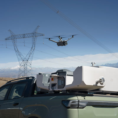
Dock 3-native design
54 minutes of flight time — measured in the context it's designed for: automated, scheduled operations from DJI Dock 3. The M4D is built to land, recharge automatically, and relaunch without human intervention on site. With dual-drone rotation, one M4D flies while a second charges, enabling continuous aerial coverage for time-sensitive monitoring.
The integrated multi-lens camera system
The M4D integrates its camera directly into the airframe: wide-angle for site overviews, medium tele for mid-range detail, 48 MP tele (1/1.5-inch CMOS, f/2.8) for close inspection at standoff distance, and a laser rangefinder. The M4TD thermal variant adds a thermal camera to this stack.
The M4D captures 5-direction oblique imagery — nadir plus four oblique angles simultaneously — making photogrammetric 3D reconstruction faster and more accurate than single-nadir capture.
FlightHub 2 routing for automated missions
Smart 3D Capture routes calculate optimal photogrammetry paths automatically. Geometric routes handle building facades. Slope routes maintain consistent ground sampling distance on inclined terrain. A trained operator plans and executes complex mapping missions without advanced photogrammetry expertise.
Who should buy the Matrice 4D
- Construction and development: automated weekly site overflights, no pilot on site required
- Infrastructure monitoring: regular inspection on a scheduled cadence via Dock 3
- Public safety: rapid dock deployment with multi-lens visual and thermal capability
- Security and surveillance: continuous aerial monitoring with dual-drone rotation
- Geospatial teams scaling up: high-throughput photogrammetry with minimal pilot time per mission
Full specification comparison
| Specification | Matrice 400 | Matrice 4D |
|---|---|---|
| Max flight time | 59 min (with H30T) | 54 min |
| Max payload | 6 kg | ~2 kg (integrated system) |
| IP rating | IP55 | IP55 |
| Dock 3 compatible | No — standalone | Yes — native |
| Transmission | O4 Enterprise Enhanced | O4+ Enterprise |
| Max range | 40 km | 25 km (FCC) |
| Obstacle sensing | Rotating LiDAR + mmWave + fisheye | LiDAR + mmWave |
| Wire detection | 12 mm @ 25 m/s | 12 mm @ 15 m/s |
| Camera system | Interchangeable payloads | Integrated multi-lens |
| Thermal option | Zenmuse H30T payload | M4TD variant |
| LiDAR option | Zenmuse L3 (6 kg capacity) | Not compatible |
| AR overlays | Power-Line, Map View, Waypoint AR | Standard |
| Relay function | No | Yes — built-in |
| Operating temp | −20°C to 50°C | −30°C to 50°C |
| Best for | Heavy payload, long endurance, manual ops | Automated, dock-based, photogrammetry |
Real-world decision scenarios
Power utility inspection team: Needs to patrol 500 km of transmission corridor with thermal and visible sensors simultaneously. The M400 with Zenmuse H30T and mmWave wire sensing is the only safe choice for energised line environments.
Construction firm with 3 active sites: Wants weekly automated overflights for progress orthomosaics with no pilot on site. The M4D with Dock 3 at each site, managed centrally through FlightHub 2, automates the entire workflow.
Mining survey team: Mapping 36 km² of terrain with dense scrub. Photogrammetry won't penetrate the canopy. The M400 with Zenmuse L3 delivers LiDAR returns through vegetation to produce bare-earth terrain models.
Mixed fleet operator: The M4D on Dock 3 handles routine monitoring autonomously. The M400 deploys for specialist missions — detailed LiDAR surveys, powerline patrols, custom sensor payloads. Both managed through a single FlightHub 2 dashboard.
What about DJI Care Enterprise?
Regardless of which platform you choose, add DJI Care Enterprise Plus to your order. For Matrice-class aircraft, Care Enterprise Plus (two replacements per year, priority shipping) is Mirrormapper's baseline recommendation. The cost of an unprotected replacement on a flagship enterprise aircraft runs into tens of thousands of dollars. Care makes the total cost of ownership predictable. Importantly: DJI Care Enterprise must be activated within the specified period of first activation. Don't wait.
→ View the DJI Matrice 400 on Mirrormapper: mirrormapper.com.au/products/dji-matrice-400 → View the DJI Matrice 4D on Mirrormapper: mirrormapper.com.au/collections/dji-matrice-4d-accessories → Shop DJI Care Enterprise plans: store.mirrormapper.com/collections/dji-enterprise-care → Request a bundle quote or consultation: mirrormapper.com.au
LiDAR vs photogrammetry: the definitive guide for enterprise drone operators
Category: Mapping & Survey | Tags: LiDAR · Photogrammetry · Zenmuse L3 · DJI Terra · Matrice 400 · 3D Mapping | Reading time: ~12 min
'Should we use LiDAR or photogrammetry?' is one of the most consequential technical decisions in a drone mapping program. Choose wrong and you either spend far more than the job requires, or deliver data that doesn't meet the accuracy specifications your client or engineer needs.
This guide gives you a complete framework for making the right call — how each technology works, where each wins, where they overlap, and when combining both in a single flight makes sense.
Photogrammetry gives you the picture. LiDAR gives you the measurement. The best programs know when each is enough.
How photogrammetry works
Photogrammetry uses overlapping photographs to reconstruct 3D structure through software. A drone captures hundreds or thousands of overlapping images. DJI Terra identifies common features between images and uses their relative positions to reconstruct the scene's 3D structure — a process called Structure-from-Motion (SfM).
Outputs include orthomosaics (geo-referenced aerial images of the entire site), Digital Surface Models (3D elevation including vegetation and structures), point clouds, 3D mesh models, and volume calculations.
The key advantage: photogrammetry uses cameras already on board your aircraft. The Matrice 4D's integrated multi-lens system is photogrammetry-optimised with no additional hardware required.
Overlap settings matter. Use a minimum of 80% front overlap and 75% side overlap. Below these thresholds, reconstruction errors and gaps are common. The M4D's 5-direction oblique capture substantially increases data density in a single pass.
How LiDAR works
LiDAR emits laser pulses and measures the return time to calculate precise distances. The Zenmuse L3 — DJI's current flagship LiDAR, released November 2025 — fires up to 2 million pulses per second with up to 16 returns per pulse. Because LiDAR measures distance directly rather than inferring it from image overlap, it has capabilities photogrammetry cannot replicate:
- Multiple returns per pulse: A single LiDAR pulse penetrates gaps in vegetation and returns multiple echoes — the first from the canopy, later ones from the ground beneath. This produces bare-earth Digital Terrain Models under dense tree cover.
- Lighting independence: LiDAR generates its own illumination and works in low light, shadow, and near-darkness.
- Absolute accuracy: The Zenmuse L3 achieves 3 cm vertical RMSE at 120 m altitude and 5 cm at 300 m — survey-grade for engineering deliverables.
- Texture-poor surfaces: Photogrammetry struggles with white concrete, still water, and sand. LiDAR returns reliably from all surface types regardless of texture.
L3 vs L2: why the upgrade matters
If you're evaluating LiDAR platforms for a new program in 2026, the Zenmuse L3 is the correct starting point. Compared to the previous L2:
- Detection range: 950 m at 10% reflectivity (L2 was 250 m)
- RGB cameras: dual 100 MP vs the L2's single camera, with 107° combined field of view
- Returns per pulse: up to 16 (L2 supported 5)
- Daily coverage: up to 100 km² at typical survey altitudes — approximately 4× the L2's practical throughput
- Wire detection: 21.6 mm steel-core aluminium stranded wire at 300 m
- L3 LiDAR reconstruction in DJI Terra is free from v5.1 onwards — no additional licence required
When photogrammetry is the right choice
- Construction site progress monitoring where visual context matters
- Volumetric calculations for open stockpiles and excavations
- Roof surveys and building facade documentation
- 3D model generation for client presentations and stakeholder reporting
- High-frequency monitoring programs where regular cadence is required
- Budget-constrained projects with no additional payload hardware budget
When LiDAR is the right choice
- Terrain modelling beneath tree canopy — powerline corridors, drainage catchments, forestry
- High-precision engineering surveys: road design, railway alignment, flood levee design
- Powerline and conductor mapping for infrastructure operators
- Flood and hydrology modelling where bare-earth accuracy is safety-critical
- Night operations or low-light missions
- Mining surveys in dust, glare, and uniform ore surface conditions
Combining both in a single flight
The Zenmuse L3 makes this the default rather than the exception. Its dual 100 MP cameras operate in sync with the LiDAR sensor, producing colourised point clouds in a single pass. At 120 m AGL, the L3's cameras deliver 1.2 cm GSD — matching the spatial resolution of a dedicated photogrammetry sensor.
DJI Terra v5.1 processes both LiDAR and RGB together at no additional cost. From v5.0 onwards, Terra also generates 3D Gaussian Splat models from the same flight data — photorealistic outputs suitable for client delivery and stakeholder review alongside the engineering-grade survey data.
Accuracy: what the numbers actually mean
Photogrammetry: Under ideal conditions — good overlap, correctly placed GCPs, correct altitude, texturally rich surface — modern photogrammetry achieves 1–3 cm horizontal and 3–5 cm vertical. Most commercial projects achieve 3–5 cm horizontal and 5–10 cm vertical, which is entirely adequate for construction monitoring and volume calculations.
LiDAR (Zenmuse L3): 4 cm horizontal RMSE and 3 cm vertical RMSE at 120 m altitude. This figure is more consistent across surface types and lighting conditions because measurement doesn't depend on image feature matching. For engineering applications, LiDAR accuracy is typically more defensible than equivalent photogrammetric data.
Ground Control Points: Both technologies require GCPs for survey-grade absolute accuracy. Minimum 5 points for small sites, 8–12 for medium, scaling proportionally for large areas. Without GCPs, photogrammetric models can suffer from systematic doming errors that produce volume calculation errors of 5–15%. Always add independent check points not used in processing to validate your accuracy claims.
Quick decision checklist
- Is vegetation between your drone and the ground? → LiDAR
- Is the deliverable going into an engineering calculation with tight tolerances? → LiDAR
- Do you need to fly at night or in low light? → LiDAR
- Is the primary output a visual orthomosaic or 3D model for stakeholder review? → Photogrammetry
- Are you monitoring a construction site on a regular schedule? → Photogrammetry (M4D + Dock 3)
- Do you need precision terrain data AND visual context? → Combined (L3 + Terra)