


Interiors, stairwells, under cover, tunnels. Walk through, and the S20 builds a colourised, RTK-georeferenced point cloud that registers cleanly with your drone data — indoor and outdoor, one continuous model, straight into CAD and BIM.
No equivalent handheld RTK SLAM scanner ships at this price in Australia. Every unit is stocked, configured and supported from Melbourne.
Discover SHARE S20 RTK


Open data, your pipeline
From field to finished cloud
Live Scanning Preview
 SHARE S20 RTK
Easy, Out of the Box
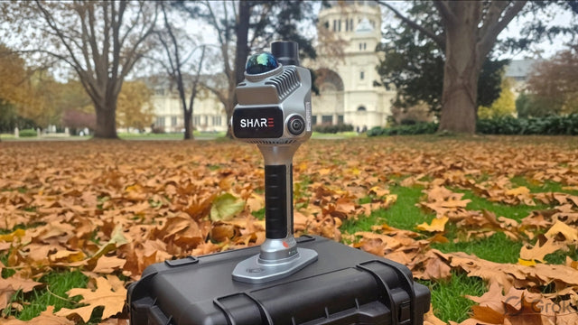

Built-in RTK GNSS
0.8 cm + 1 ppm horizontal / 1.5 cm + 1 ppm vertical positioning. Direct georeferencing — no GCPs with RTK fix; positioning plate included for GNSS-denied scans.

Advanced LiDAR
200,000 pts/sec at 10 Hz, tilted 25° for maximum coverage. Range 0.1–70 m. Real-time or post-processed solve.

Fused LiDAR + Visual SLAM
Two SLAM engines working together hold accuracy through stairwells, tunnels and feature-poor spaces where single-sensor scanners drift.
Dual 1″ Cameras, Mechanical Shutter
16MP per lens, global exposure synced to the second with position data — true-colour clouds with no smear, and photos sharp enough for photogrammetry and 3DGS models.

Open Data
Full raw data saved and an open hardware interface — run your own SLAM, generate mesh models, or mount it on robotic platforms.

Built for the Field
150-minute battery, 256 GB expandable storage, Wi-Fi 6, –20 °C to +50 °C. Aluminium body just over 1 kg.


Compare Models
| Product Name |
 SHARE S20 RTKSurvey-grade everywhere with RTK fix in seconds, deliverable before you leave site.$7,999.00
Selected
SHARE S20 RTKSurvey-grade everywhere with RTK fix in seconds, deliverable before you leave site.$7,999.00
Selected
| ||
|---|---|---|---|
| Battery Life | 180 minutes | 150 minutes | |
| Camera Resolution | 2.3MP × 2 | 16MP × 2 | |
| Camera Sensor | 6.96 × 4.96mm; 1/2.6" | 13.13 × 8.76mm; 1-inch | |
| Shutter Type | Electronic global shutter | Mechanical shutter / electronic shutter | |
| Points per Second | 200,000 pts/s | ||
| Range | 0.1–40m @ 10% reflectivity; 0.1–70m @ 80% reflectivity | ||
| RTK Configuration | None | Detachable (standard) | Built-in (standard) |
| RTK Accuracy | None | Horizontal 0.8cm + 1ppm; vertical 1.5cm + 1ppm | |
| Point Cloud Thickness | Within 1cm | ||
| Absolute Accuracy | Better than 5cm | ||
| Relative Accuracy | Better than 1cm | ||


FAQ
Questions, answered
Buying & price
Why is the Australian price different from SHARE's US store?
What's the difference between the S20 SE, S20 SE RTK and SLAM S20 RTK?
Is training included?
Accuracy
How accurate is the S20 really? I've seen 0.8 cm and 5 cm quoted.
Do I need ground control points?
Does it work where there's no GNSS signal at all?
Workflow & data
Can I merge S20 scans with my drone data?
What file formats does it output, and will they open in my software?
Do I have to process in SHARE's software?
How do I get RTK corrections in the field?
In the field
How long does it run, and how much can I scan in a session?
What conditions can it handle?
Support
What warranty and support do I get?

Put the scanner on four legs
Pair the S20 RTK with a Unitree robot dog and walk georeferenced point clouds through tunnels, stopes, and hazardous ground, no operator inside. We'll integrate the payload and RTK for you.