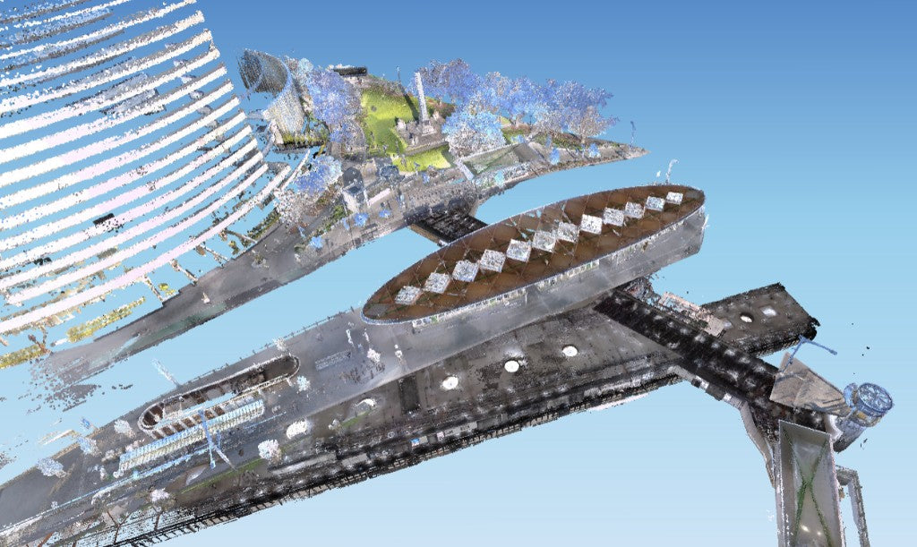
The cloud can look finished and still be wrong in the one place that matters. Rooms sit together. Then the stairwell sits off the floor below it, or the start mark and the end mark are no longer the same point. That is the trajectory, not a missing camera and not a ranging spec. This post is how a handheld scanner holds that line, and the ways it lets go.
The short version of SLAM is in how SLAM mapping works. That piece is the intro. This one is the field version: laser, cameras, IMU, loops, and what to watch on the phone.
A tight cloud is not the same as a mapped cloud
A locally consistent model can still carry a bent spine. You often only see the bend once you put the cloud on a datum. Keitaanniemi and colleagues scanned a campus with a GeoSLAM ZEB-REVO for about ten minutes. Local rooms looked usable. After they georeferenced it, the drift showed up, mainly vertical, largest in the middle of the path, around 10 centimetres before they split the trajectory and post-processed. The lesson is not a millimetre spec. It is that "it looked fine on the laptop" is not a coordinate.
In Australia the grid most engineering work sits on is MGA2020. AUSCORS is how a rover gets a kinematic fix outdoors. ICSM Special Publication 1 is the control standard. None of those make a relative SLAM model a cadastral survey. Name which number you are quoting before you answer a client: how well the cloud agrees with itself, or where it sits on the map.
The laser matches walls. Paint does not count.
LiDAR SLAM holds the path by matching successive sweeps of surfaces: corners, columns, door frames, the junction of floor and wall. It needs geometry in more than one direction. A long smooth corridor, a culvert, a car park with nothing to lock onto: the match along the tube is weak. Emesent, writing about Hovermap in tunnels, says a lack of features can make SLAM slip and leave a cloud you cannot use. A painted stripe is not a feature. Geometry is.
You also have to be close enough for the match to be distinctive. The sheet can quote tens of metres of range. The trajectory still needs overlapping surfaces in the band you are actually using. Stand off from a dark far wall and you starve the matcher, not just thin the cloud. That ranging story is in LiDAR range at 10 percent and 80 percent reflectivity.
The cameras are a second vote. Glass can lie.
Visual SLAM tracks texture in the cameras. Repeating doors, skirting, a run of identical rooms. In a featured plant room the laser and the cameras usually agree. In a plain concrete corridor the laser match is weak, so the cameras do more of the work. Glass at the end of a corridor, a mirror, a window onto moving traffic: the cameras can lock onto a reflection.
Payo tested this on an S20, not on the units on our floor today, in a narrow hotel corridor across three floors at a slow pace. His clip looked tight floor to floor. Start and end were still apart because he forgot the floor mark. Treat that as his corridor test, not a published stairwell spec. He also said in that video that the smaller handheld of that generation had no visual SLAM. That was true of the unit he had then. The current pair in that line both run fused LiDAR and visual SLAM.
If the live preview starts painting a second copy of a wall, stop. That is the matcher holding two ideas of where you are.
What to watch on the phone
The preview is the check you get in the building, not a pretty render. Watch the path line, not only the colour. If the line jumps, or a wall you just passed appears twice, you have already lost the match. Stop, recapture that floor, do not hope the office software will stitch the kink later.
Close a loop where there is something to recognise: a stair landing, a plant room, a lift lobby. Recrossing a blank corridor is not a loop. Outdoors, recrossing the car park does less than an RTK fix. Indoors, finish where you started if you can, on a feature, not in a cupboard.
Pace is part of the check. About a metre a second. Faster looks fine in the moment and shows up as a bent stair later. If the unit warns you are moving too fast, it means it. Same for a doorway: two or three seconds in the opening so both rooms are in one sweep.
None of this replaces a check against control you trust. It is how you notice the path has gone before you leave the site.
The IMU fills gaps. It does not invent a room.
The IMU (inertial measurement unit) measures rotation and acceleration. Through a doorway, or between laser matches, it keeps the pose from jumping. It also accumulates error. Libro, teaching Mid-360 class field craft (same Livox family as the current handhelds we sell, not a claim about those units), stands the scanner still for about 10 to 30 seconds at the start, pointed at something with features, then moves at about 1 metre per second or slower. He tried the same idea faster, on a motorcycle. The cloud stitched. Check shots were about 20 centimetres out vertically. The same site at a steady pace came back to a few centimetres. Speed starves the overlap the matcher needs.
Doorways: pause two to three seconds in the opening so the sensor can see both rooms. Dead ends: do not spin; back out the way you came. Small rooms: reach in rather than turning around inside. Start facing a feature, not a blank wall. Payo's warehouse clip (same S20, four floors, a blocked stair, RTK on the roof that would not hold) is a record of what the path does when the loops and the satellites are both compromised, not a pass mark.
A loop is a correction. A slam break is a recapture.
Drift is the slow bend. Loop closure is the scanner recognising a place it has seen before and pulling the line back. Recross your path in a place with geometry. A loop in a blank corridor does little.
A slam break is different. The algorithm loses the map so badly that the estimate is wrong: a kink, a duplicated room, a path that is not the building. Post-processing can sometimes reduce drift. A slam break is usually a recapture.
Outdoors, loops do less than people hope. RTK matters more. Indoors you want to recross your own path, then let the solver use that recross.
GNSS stops at the door
RTK on a handheld unit, tied to AUSCORS NTRIP, is how outdoor legs sit on MGA2020 while the receiver is fixed. Inside, under a deep canopy, or into a basement, the satellites drop. SLAM carries the line from the last good fix. If that last fix was already soft, the indoor leg inherits it. Under forest canopy a 2024 study got no fixed solutions. That story is in handheld LiDAR for forest plots and urban trees. Do not quote the open-sky RTK centimetre figures as an interior absolute.
A plate on a known point, or a total station tie, is still how you snap a GPS-denied model back to the site datum. RTK expands the outdoor legs. It does not retire control, and it does not make a relative model a boundary survey.
What actually breaks it
Feature-poor corridors, culverts, car parks and glass. Pace above about a metre a second. Spinning in a cupboard. Starting on a blank wall. A live preview that paints two copies of a wall. A loop that recrosses in a place with no geometry. Calling a slam break "a bit of drift" and hoping the office software will unkink it. Treating a clean relative cloud as an MGA2020 coordinate. Hoping GNSS will hold in a stairwell.
We have not published a stairwell check on the units we sell. The numbers above come from a campus study, Hovermap field notes, and named YouTube tests. They are not a substitute for a check on your own site against control you trust.
Where we stand
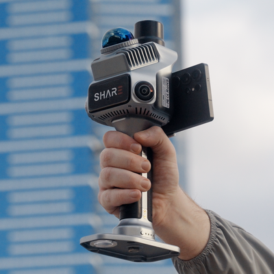
We sell and set up the SHARE C1, C1 Pro and C10 handheld scanners. The two smaller units both run fused LiDAR and visual SLAM; the middle one adds integrated RTK. The long-range unit is for when the far wall goes thin. We have not published our own stairwell or corridor RMSE on those units. A scanner of the same class should be expected to fail in the same places until someone measures it.
If you already have a LAS, send it and we will tell you where the trajectory slipped.
Read next: how SLAM mapping works · handheld scan checklist · LiDAR range and reflectivity