
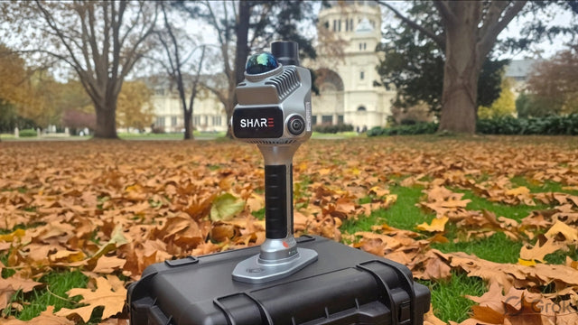
SHARE C10-32 Pro
The professional flagship of the C10 series. 32-channel LiDAR with a 300-metre measuring range, four 20 MP cameras with an independent 5 nm ISP, and a lighter 2328 g chassis. Built for mining areas, karst caves, ancient architecture, and infrastructure projects where you need both close-up detail and distant structures captured in one sweep.
Ground Truth
Discover SHARE C10-32 Pro

1x
S100 Pro LiDAR Scanner

1x
S100 Storage Box

1x
S100 1TB SSD
›

2x
S100 Battery
›

1x
Charger

1x
Data Cable

1x
Data Cable

1x
Data Cable

1x
SHARE User Manual
Compare Models
| Product Name | |||
|---|---|---|---|
| LiDAR Channels | 16 | 32 | |
| Point Cloud Rate | 320,000 pts/s | 640,000 pts/s | |
| Measuring Range | 0.05 ~ 120 m | 0.05 ~ 120 m | 0.5 ~ 300 m |
| Camera Quantity | 2 | 4 | |
| Sensor Size | 1-inch (13.13×8.76mm); Pixel Size 2.4μm | ||
| Effective Pixels | 16 MP | 20 MP | |
| Dimensions | 386.8mm×152.7mm×174.4mm | ||
| Weight | 2438g | 2328g | |
| Wi-Fi | Wi-Fi 6, 2.4G/5G; 20m | ||
| Storage | 1TB SSD | ||
| RTK Accuracy | Horizontal 0.8cm+1ppm; Vertical 1.5cm+1ppm | ||
| Backpack System | Standard Ergonomic Backpack System | ||
| Battery Capacity | 49.436Wh (3400mAh) × 2 | ||
| Operating Time | Approx. 180 mins | ||
| Point Cloud Thickness | Within 5mm | ||
| Relative Accuracy | Better than 1cm | ||
| Absolute Accuracy | Better than 5cm | ||


FAQ
Questions, answered
Choosing a model
Should I buy the S100 or the S20?
Pick by site scale. The S20 ($7,999) is a 1 kg handheld for interiors, as-builts and spaces up to 70 m range — ideal where you're walking tight spaces all day. The S100 Series is the heavy-lift option: a backpack-mounted 16- or 32-channel scanner with 120–300 m range, up to 640,000 points per second, a 1 TB SSD and 3-hour runtime, built for mines, tunnels, large facades and full-site capture. If most of your work is indoors and under 70 m, the S20 does it for less money and less weight.
What's the difference between the S100-16, S100-32 and S100-32 PRO?
Channel count and range. The S100-16 runs 16 LiDAR channels at 320,000 points per second; the S100-32 doubles that to 32 channels and 640,000 points per second — both range to 120 m. The S100-32 PRO extends range to 300 m and upgrades imaging from two 16MP cameras to four 20MP wide-angle cameras with a dedicated image processor, for wider coverage and finer point cloud colour. More channels means denser clouds in fewer passes; choose the 16 for budget, the 32 for production density, the PRO for big open sites.
Who actually needs the 300 m range of the S100-32 PRO?
Anyone scanning things they can't walk up to: open-cut pits, stockpiles, quarry walls, tall facades, bridge spans and large industrial structures. At 300 m you capture from the ground what would otherwise need a drone flight or a tripod scanner — and because it's still SLAM, you keep walking while you do it. If your sites fit inside 120 m, the standard S100-32 saves you money.
Buying & price
Why buy the S100 from Mirrormapper instead of SHARE's overseas store?
By the time SHARE's direct price converts to Australian dollars and clears shipping and import GST, you've spent close to the local price — and you own a scanner with no Australian warranty, no training and no one local to call. Buying from us gets you a GST tax invoice, Australian Consumer Law protection, hands-on handover from our Melbourne team, and support from the engineers who set up your unit.
Accuracy
The S100 quotes the same accuracy as the S20 — so what am I paying extra for?
Fair question. The headline RTK (0.8 cm + 1 ppm horizontal) and absolute accuracy (better than 5 cm) specs match the S20 — what changes is the cloud itself. The S100 holds point cloud thickness within 5 mm (vs 1 cm on the S20), captures up to 640,000 points per second across 16 or 32 channels, and reaches 120–300 m instead of 70 m. You're paying for density, cleaner surfaces, range and coverage speed — not a different accuracy class.
Do I need ground control points?
Not for georeferencing when you have an RTK fixed solution (AUSCORS NTRIP corrections). Where you do want control, the S100 has a trick the S20 doesn't: visible laser control point acquisition — aim the laser dot at a known point and capture it, even on rough terrain like mine benches and caves where placing targets is impractical. For deliverables with a stated accuracy spec, independent check shots remain standard QA.
What if there's no RTK coverage at my site — mountains, deserts, underground?
The S100 supports PPK processing as well as RTK. Log raw GNSS data against your own base station or a cloud PPK service, and georeference the scan in post-processing — no live corrections required. Fully GNSS-denied sections (tunnels, underground workings) are carried by the fused SLAM trajectory and tied to coordinates with laser-acquired control points.
Workflow & data
Can I merge S100 scans with my drone data?
Yes. The S100 outputs RTK- or PPK-georeferenced clouds in real-world coordinates, so handheld and aerial datasets register into one continuous model — pit floors and underground sections from the S100, aerial overview from the drone. With 300 m range on the PRO, the overlap zone between ground and air capture gets generous.
How much data does it generate, and how do I get it off the unit?
A lot — that's why it ships with a 1 TB high-speed SSD as standard, enough for large multi-day surveys. Offload runs at over 1 GB/s, so a full day's capture transfers in minutes, not hours. Processing runs through SHARE PointClouds Studio on desktop, with point clouds exporting in standard formats for CAD, BIM and GIS packages.
In the field
At 2.4 kg, isn't it heavy to carry all day?
You don't hand-carry it — the S100 ships with an ergonomic backpack system as standard, putting the weight on your shoulders and hips rather than your wrist. Operators run multi-hour sessions in mines and on large sites; that's the workload it was designed around. If your jobs are short indoor scans, the 1 kg S20 is the better tool.
How long does it run on a charge?
Up to 3 hours on the dual-battery system, and the batteries hot-swap — so with spares you scan continuously without powering down. Combined with the 1 TB SSD, the practical limit on a session is your legs, not the hardware.
Support
Is training included?
Yes, in Melbourne. Every S100 bought from us includes a hands-on handover from our Melbourne team covering AUSCORS NTRIP setup, PPK workflow, your first scan and the data pipeline into your CAD/BIM software. Training is also available in other major Australian cities for an additional fee.
What warranty and support do I get?
A 12-month warranty backed by Australian Consumer Law, with support from our Melbourne team — phone, email, and the same engineers who did your handover.
Reviews
What customers are saying
Real feedback from teams using this equipment in the field.
Be the first to share your experience
Teams like yours rely on real field feedback before they buy. A quick review helps the next operator choose with confidence.
Takes about 2 minutes · Verified by Judge.me

Scan something you actually need
Book a free on-site demo. We'll bring the S20, scan your site, and hand you the point cloud before we leave.